
Inundated by colonial misconceptions
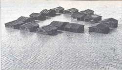 FLOODS have ravaged India from times immemorial and people have controlled and turned them into beneficial processes. But today they are seen as catastrophic events that are to be forcefully contained by dams and embankments.
This perception has its roots in India's colonial past, according to recent evidence from Orissa. Floods, famines and crop failures were thought to be merely phenomena that occurred because of the unpredictable vagaries of nature. This whimsy then had to be overcome, if the most pressing objective-collecting the maximising revenue possible-was to be. But this short-term objective and misconception about the role of floods created havoc among the peasantry. Unfortunately, imperceptions about floods have not changed much since the colonial period.
Coastal Orissa, consisting of the districts of Cuttack, Puri and Balasore, came under colonial rule in 1803, but it took till 1834 to set the first definite guidelines for revenue collection. From 1836 and 1843 the entire province was surveyed and mapped at the cost of Rs 20,36,348, but the revenue increased by only Rs 34,680.
In the process of surveying, the colonial administration come to grips with a unique ecological setting. Andrew Stirling, an administrator-geographer, wrote in his book An Account, Geographical, Statistical and Historical, of Orissa Proper, or Cuttack published in 1822, that a striking characteristic of the coastal tract was its river system, which was "peculiarly subject to inundation".
This river system consists of the Mahanadi, the Brahmani and the Baitarani, which drain into the Bay of Bengal. They often shifted course, overflowed and inundated villages and fields. Besides, the water torrents with their silt load destroyed or altered the topography of the land.
The frequent changes in the river system evoked a tremendous sense of chaos in the colonial mind. The ever-changing character of this unique deltaic region subverted the continuity of British rule and disrupted its solidity. Remissions of revenue on account of floods between 1852 and 1867 amounted to L26, 472 per year, a substantial 16 per cent of the land tax collected in Orissa. Panicked British policy makers, obsessed with revenue collection and profit, began looking for solutions.
By the 1850s, new strategy, based on engineering solutions to prevent rivers from overflowing their banks, emerged. The new approach differed from the earlier thinking that consisted of approximating the costs incurred from flood damage and correspondingly remitting tax amounts as relief. Flood waters were now to be "controlled", "regulated" or "brought under absolute subjection".
Detailed study In 1856, J C Harris, the executive engineer of Cuttack conducted a detailed study of the Mahanadi and its tributaries. Harris argued that the floods in the Mahanadi delta were caused by the incapacity of the river to carry its silt load. As a remedy he suggested that a spur be constructed at Naraje to divert water away from the river Kathjuri, a tributary of the Mahanadi, to increase the latter's flow, enabling it to clear the silt load and retain the water within its banks.
This study led the administration to develop systematic and scientific monitoring of the river system of coastal Orissa. Seveal stations were established to measure the depthsof the rivers and their water speed.
Irrigation engineer Arthur Cotton, after touring Orissa in 1858, suggested investments in a more comprehensive programme to regular rivers through a system of weirs, embankments and canals. Cotton linked flood and drought to the loss of revenue and his solution lay in transforming these losses into profits through "Western knowledge and technology". Active intervention through technological fixes, as opposed to a remission-centric policy, became the new focus in flood policies.
However, despite this apparent shift in the policy of dealing with floods, there was a remarkable continuity. From 1803 to the Report of the Orissa Flood Committee 1928, the discussion on floods was centred on the event as opposed to the process.
There were, nevertheless, some perceptive officials who saw the floods as essentially beneficial to the delta. "Indeed, a heavy flood, however severe and long continued it may be, seems always to contain in itself an element of future compensation for present loss by the increased fertility," said British historian G Toynbee.
Floods were seen as s blessing in disguise as the destruction of one season was compensated by the unusual abundance of the next. But the British revenue system was rigid in its demands. Instalments were collected in November and April regardless of the circumstance. A flexible revenue system, like of the Maratha regime (1751-1803)-synchronised with the ruthless policy of forcing cultivators to pay on fixed dates.
Canals constructed
To prevent floods from occurring, the colonial government adopted Cotton's scheme. In 1863, a system of weirs and canals began to be constructed by the East India Irrigation Company (EIIC). Popularly known as the Orissa scheme, these canals were supposed to irrigate area of nearly 1 million ha and yield a 21 per cent return on investments of L200, 000 made by private British speculators who bought EIIC shares.
The Orissa scheme proved to be a colossal failure and EIIC did not recover its costs. In 1866, the first irrigation lease was signed for an area of only 1.4 ha. At the end of February 1887, the area irrigated was just 2,702 ha at a time when there was sufficient water to irrigate 24,291 ha. At the end of October 1867, EIIC was prepared to supply water for 61,943 ha but the area under irrigation was only 3,982 ha. There was a complete mismatch of demand and supply.
Since the peasantry could not pay the land revenue, the British revenue department failed to make profits. The entire gross revenue from the commencement of the project amounted to a measly Rs 4,339.
There were other adverse consequences. By sealing rivers within their banks, cultivators were denied access to the rich deposits of fertilising silt. Floods continued to ravage the land. The unplanned construction of embankments interfered with natural drainage lines, diverted water currents to previously unaffected areas and thus complicated flood levels.
In 1904, the colonial government finally realised the inefficiency of maintaining these embankments, it not only washed its hands off the problem but secretly set about dismantling some of these embankments. Seventy years after Cotton published his "scientific" study, the flood committee of 1928 wrote, "Orissa is a deltaic country and in such a country floods are inevitable. They are nature's method of creating new land and it is useless to attempt to thwart her in her working." Little heed was paid to this wisdom.
The policy of containing floods still continues. Orissa remains one of the most flood-prone areas in India, her sad experience with flood control somehow forgotten as history continues to repeat itself.
Rohan D' Souza wrote this piece based on his M Phil dissertation submitted to the Jawaharlal Nehru University's Centre for Historical Studies in 1993.