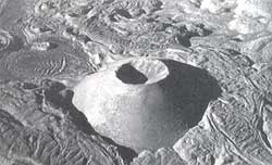
The lost planet
 AIRBORNE archaeology' is the theme that the artist-photographer Marilyn Bridges tried to convey in her recent exhibition of photographs. The exhibits were on view in the American Museum of Natural History's Akeley Gallery, Central Park West at 79th Street in New York City, from December 1, 1995, to February 1, 1996. Bridges has spent nearly two decades capturing impressions of landscapes from almost every kind of aircraft. Her photographs display an exquisite sense of composition and form, bearing a touch of the cultural ambience of the ancient region.
The exhibition was based on Bridges' book of the same title, including 54 black-and- white aerial photographs which showed the remains of Pre-Colombian Peru (200 BC-AD 600) juxtaposed with modern Peruvian landscape.
The three sections of the exhibition, Highlands, South Coast and North Coast, captured the respect and sentiment of the ancient builders for their natural surroundings.
Bridges travelled through Peru on the South Coast and captured the mysterious Nazca lines - the enormous designs carved on the Peruvian landscape which are clearly visible from hundreds of feet in the air. Some of these images measure more than 100 feet in length. A few of her photographs also include images of Spanish invaders, Moche Pyramids of Sun and Moon, and Sipan - a site having the richest tombs ever excavated in the Western Hemisphere.
The Highlands photographs featured a spectacular view of Tiwanaku, the world's highest ancient urban centre, rising more than 12,000 ft above the sea level. According to the Inca religion, Tiwanaku is the abode of the creator-god, Wirakocha. Among other significant sites that Bridges photographed is the island of the Sun along Lake Titicaca -one of the holiest sites for the Inca people.
Bridges shot her photographs at an altitude of 400-500 ft above land, giving the images intimacy and revealing the vastness of natural and human-made features. She shoots through the open door of a plane, which she often flies herself until another pilot takes over at very low altitudes.
Records suggest that Bridges was not the first to take aerial photographs in Peru. In 1932, geologist Robert Shippee and former navy pilot and aerial photographer George R Johnson flew over Peru to record Andean landforms, archeological sites and ancient terracing and irrigation systems, especially some archeological sites of the Chincha Valley on Peru's south coast. This was the first time that airborne photography was attempted at in a fashion followed by modern satellites and spacecrafts.
But sadly, according to Criag Morris, dean of science and curator of South American archeology at the American Museum of Natural History, one may not now recognise the ancient sites in the photographs, as these were bulldozed in the '50s, to acquire agricultural land.
Related Content
- The inequality virus: Bringing together a world torn apart by coronavirus through a fair, just and sustainable economy
- Deforestation fronts: drivers and responses in a changing world
- Sulfur dioxide (SO2) pollution hotspots in South Africa: 2019-2020
- WHO Manifesto for a healthy recovery from COVID-19
- Working with the environment to protect people: UNEP’s Covid-19 response
- Working With the Environment to Protect People UNEP’s COVID-19 Response
