
Off course
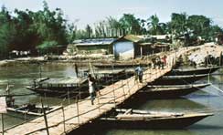 jia bharali, a tributary of the Brahmaputra in Assam is changing course and heading towards Tezpur, causing panic among residents, the district administration and university officials because both the town and the university are in the line of fire.
The high-velocity river is wreaking havoc and has washed away offices, schools, colleges and buildings including the district home guard command office and the local police outpost. More than 15,000 persons have either been displaced or rendered homeless on account of the river changing its course. Tezpur Central University could well be the river's next target.
The approach road to Tezpur Central University in Sonitpur district wears a deserted look. Partly and fully submerged buildings can be seen all around. The situation has deteriorated over the last couple of months. The anxious residents fear the worst for Tezpur.
Jia Bharali is responsible for contributing about 4 per cent of the Tezpur's water requirement. The river flows down from Arunachal Pradesh, and runs through the middle of Sonitpur district following a 66-km course through Assam.
With the river changing its course, over 1,100 hectare (ha) of agricultural land has become absolutely non-productive due to the deposition of sand over fertile land. Prosperous farmers have become poor labourers, with no land to cultivate. Three villages, Bihia gaon, Singitoli and Gotaimari, have been nearly washed out. More than 15,000 people have been rendered landless and homeless, and forced to take shelter on roads and in relief camps.
The current problem has its roots in 1998, when, for the first time, severe flooding of the Brahmaputra and Jia Bharali broke embankments, totally flooding several villages. The water resource authorities did not take these floods seriously and resorted to temporary measures like stacking large boulders to deflect floodwater. Similarly, locally available bamboo-porcupine fences (sticking out of the water like porcupine quills) were erected to control the flood situation. The situation became alarming in 2002, when, mora bharali, the dry extended wing of Jia Bharali became active on account of overflow from the river. Once again, the department used the same temporary relief measures they had earlier used and failed to contain the floodwaters.
Officials are quick to point out that the river is slowly changing its course and moving towards Tezpur town. "The biggest setback has been the washing away of the pwd concrete bridge at Pach Mile area, which has completely disrupted communication,' says an executive engineer of the Public Works Department. Other damages include the erosion of the embankment at three points because of the high velocity and flashy nature of the river.' The Pach Mile area of Sonitpur district, covers an area of about 4 sq km and is inhabited by over 25,000 persons.
Senior officials of the water resource department headquarters say that department applied for a grant of Rs 31 crore, in 2004 to take permanent steps to solve the problem but have been only given a grant of Rs.6.5 crore by the National Bank for Agriculture and Rural Development (nabard). The officials add that tender notices have been issued and relief and rehabilitation work will commence shortly.
The problem The North Eastern Regional Institute of Water and Land Management (neriwalm) has completed in-depth research into the problem caused by the river changing its course. It carried out field studies and processed data from satellite images and came to the conclusion that Jia Bharali is changing course towards its right bank. The migratory nature of the river was discovered by superimposing multi-temporal satellite images. The satellite data confirms acute bank erosion at the rate of around 1.3 km per year, in the Pach Mile area.
When a comparative study was undertaken on the rate of erosion it was observed that the erosion was much lesser during the period 1988-1998 when compared with the period 1998-2002. Senior researchers at neriwalm blame the Piedmont zone, which is the boundary of the Eurasian and Gondwana plates, for the problem. The current change is attributed to the Gondwana plate advancing and entering beneath the Eurasian plate by a few centimetres every year. Secondly, the region is in the debouchment zone of the river. These two factors make the zone
Related Content
- Order of the National Green Tribunal regarding pollution of Godavari river, Telangana, 29/05/2025
- World health statistics 2025: Monitoring health for the SDGs, Sustainable Development Goals
- Order of the National Green Tribunal regarding rising pollution in the Vishaw stream, a tributary of the river Jhelum due to illegal mining, Jammu & Kashmir, 23/04/2025
- Compliance affidavit by Tahasildar, Jaleswar, District Balasore regarding sand walls being erected in Subarnarekha, Balasore, Odisha, 22/04/2025
- Energy and AI
- Interconnected disaster risks: Turning over a new leaf (2025 report)