
The eye in the sky
 REMOTE sensing is slowly changing the contours of planning in India. In time, it could do away with conventional methods of data collection involving laborious field studies and replace dusty files in the large cupboards of officialdom with computer tapes, discs and video monitors. Providing such relatively easy access to vast amounts of data will be of immense help to the country"s planners.
How is remote sensing accomplished? By using satellites to study conditions on the earth"s surface from afar and without establishing direct contact with it.
In a world wherein space technology is the preserve of rich nations, India is one of the few developing countries to have its own space satellite systems and ground facilities, and the expertise to analyse data and apply it. "The Indian space programme," Space Commission chairman U R Rao once observed, "has made great strides in using the sophisticated remote sensing technology to maximally benefit the grassroots of the nation." The Indian space programme currently costs more than Rs 500 crore annually.
Remote sensing technology has developed rapidly since India started receiving data from LANDSAT 1, launched in 1972 by the US National Aeronautics and Space Administration (NASA). N V Madhavan Unni, who heads the forestry division of the Hyderabad-based National Remote Sensing Agency (NRSA), comments, "Today, India"s capacity to process, analyse and interpret remote-sensed data, is comparable to the best in the world."
The Indian remote sensing satellite project, including IRS-1A and IRS-1B, has cost more than Rs 106 crore to date out of a sanctioned budget of Rs 115 crore.
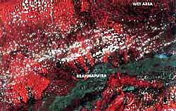
Indian satellite
India"s first, indigenous, remote sensing satellite was named Indian Remote Sensing Satellite (IRS-1A), and launched with the assistance of the erstwhile Soviet Union on March 17, 1988. This was followed by launching IRS-1B on August 29, 1991, again with Soviet help. These satellites have helped in reducing India"s dependence on foreign satellite services and products. The two IRS satellites form the core of the National Natural Resources Management System (NNRMS), a programme that uses data provided by remote sensing satellites for mapping, monitoring and managing natural resources under the aegis of the Department of Space (DOS).
The NNRMS expects to integrate remote sensing information with such other data as socioeconomic indicators and Plan targets. But, so far, progress has been slow, says N K Mathur, joint advisor in the Planning Commission, because of the difficulties encountered in pooling data and information from various departments that have hitherto functioned autonomously. However, once the entire system is operating efficiently, it would vastly improve the scope for agroclimatic zonal planning, which involves planning for a particular region keeping in mind its geographical and climatic characteristics. As a result, Mathur noted, "The cost of development itself will go down."
Several agencies are involved in implementing the national remote sensing programme. The DOS, together with the ISRO, is the nodal agency for establishing an operational remote sensing system in India. To take care of the operational needs of remote sensing, the NRSA was established in 1975 at Hyderabad. NRSA is responsible for acquiring, processing and disseminating data obtained from satellite and aerial remote sensing data, and for the training of user-scientists in various applications.
The Space Applications Centre (SAC) in Ahmedabad, an ISRO agency, pursues research and development programmes in the area of space technology and its applications, designing satellites and payloads.
Complementing NRSA"s functioning is the Indian Institute of Remote Sensing (IIRS) at Dehra Dun, where Indian and foreign personnel receive training in utilising this technology. There are five more regional remote sensing service centres (RRSSC) in Bangalore, Nagpur, Kharagpur, Jodhpur and Dehra Dun. In addition, almost all the states have set up their own remote sensing cells.
Difficult task
Introducing remote sensing technology in India has not been easy. Initially, its immense potential posed a threat to established institutions and their entrenched bureaucracy, who feared replacement of their more labour-intensive methods of data collection would result in unemployment. Some, like M S Bhatia, an economic advisor to the ministry of agriculture, expressed serious doubts about its reliability and relevance to Indian conditions. Questioning the efficacy of the technology in estimating accurately crop acreage and yield estimations, Bhatia noted, "The technology certainly needs to be perfected. It will be a long time before remote sensing techniques will be able to reach the accuracy levels of conventional techniques of yield estimation. These conventional methods based on intensive field studies and crop breeding techniques were developed over many decades and have narrowed the margin of error to less than 2 per cent." Urging caution in hastily replacing conventional methods with the new remote sensing technology, Bhatia warned of the danger of throwing the baby out with the bathwater.
Reflecting Bhatia"s fears was K P C Rana, head of the Delhi centre of the National Bureau of Soil Survey and Land Use Planning. "India," he maintained, "has developed a very sophisticated and thorough method of collecting and maintaining soil and land use information. For a quick macroanalysis, remote sensed data is very useful, but for detailed study of soil type, class and depth, conventional methods are so far the only answer."
But Bhatia agreed remote sensing can have specific applications, such as studying crop diseases and pests that together cause an annual loss of more than Rs 5,000 crore. One of the first breakthroughs in using remote sensing techniques was in the study of a disease that was affecting coconut trees in coastal Kerala in the early 1980s. Satellite imagery supplied to the state government enabled quick identification of the affected regions and appropriate remedial action was taken.
Sometimes, NRSA data has sparked extreme controversy as, for instance, when NRSA raised a storm in forestry circles in 1983 by publishing an estimate of forest cover in India, based on LANDSAT satellite imagery covering 1980-82. NRSA set the country"s total forest cover at 46.35 million hectares (mha), or 14.1 per cent per cent of the country"s geographical area. NRSA also stated that satellite imagery disclosed scientifically for the first time that India"s forest cover had declined alarmingly, with dense or closed forests now covering only 10.96 per cent of the country"s geographical area.
The Forest Department refused to accept the figures and asserted that NRSA estimates were very much on the low side. The Forest Survey of India (FSI), an agency of the Forest Department, using conventional techniques involving land records and ground surveys, estimated India"s forest cover at 64.20 mha, or 19.52 per cent of its geographical area. The FSI insisted in its State of the Forest Report, that "the NRSA estimates suffered from many inadequacies".
In a reconciliation exercise carried out by NRSA and FSI in 1984, it became clear that the FSI wanted to include in its estimate certain types of degraded forests, which had been omitted by NRSA. Going by FSI parameters, which raised open forest area from 10.06 mha to 27.66 mha, the total forest cover became 19.52 per cent. However, the FSI did not dispute NRSA"s figure of 10.96 per cent for closed or dense forest cover, which in fact represented a decline from 14.12 per cent in 1972-75.
But B B Vohra, former chairperson of the Advisory Board on Energy, considers the country"s method of assessing its forest wealth as still rather primitive. Says Vohra, "We are incapable of describing our forest assets in a scientific and quantitative manner. In estimating the forest cover of the country, only dense forest cover should be taken."
Unni agrees that a radical change in estimating India"s forest cover is needed because of various human influences at the micro-level, such as indiscriminate deforestation for extraction of forest produce, agriculture, grazing, habitation, mining, river valley projects and so on. "In this situation, the conventional survey and enumeration systems have lost their credence," he asserted.
Considering NRSA is an independent agency, some contend it would be more appropriate if it would monitor forest cover, instead of merely channelising satellite data to the FSI which then interprets the data in its own way. NRSA monitoring, they add, would act as a check on the FSI because the latter has clearly failed to stem the decline in the country"s forest wealth -- a decline that even the government concedes.
More controversies
Remote sensing has touched off other controversies as well. In one instance, remote sensing was criticised as a means of centralising information and data on resources and natural disasters in the Union government, at the expense of the states. Though all states have their own remote sensing cells, they are constrained by limited finance and facilities and so are dependent on the Centre for their remote sensing needs. Such a situation is fraught with tension for although remote sensing was a boon to Central and state authorities in monitoring and tackling drought, it created problems when drought data was made available. Recalls S T Chari, head of the Water Resources Division, "NRSA was asked to mute its drought forecasts and not go public with them because drought has various implications -- political, administrative and financial."
The problem is that over the years, cash-strapped state governments have been seen as consistently overstating damage caused by drought and floods and manipulating data from conventional sources to extract the maximum in financial assistance and concessions from the Centre. In turn, the Centre has been equally adept in conceding much less than the relief demanded by a state. The Centre has also been proved often as being more partial to those states it governs through the party"s state units. All this clearly shows how intensely the issue of data collection has been politicised. In such circumstances, remote sensing can play a crucial role in verifying claims and counter-claims by the states and the Centre, especially when natural disasters strike.
Agricultural data collection is undoubtedly the most important of all the many uses that remote sensing has been put to in India. It has been used since the mid-1970s to predict crop acreage and the yield estimates of wheat, rice, groundnut and sorghum in selected regions. Similar remote sensing exercises were subsequently carried out in the cotton-growing districts of Punjab, Haryana, Gujarat, Madhya Pradesh and Maharashtra. Though forecasting of crop production estimates at the national level began in 1986, it was only in 1988 that the Union ministry of agriculture formally accepted the technology.
Using digital data derived from IRS-1A, scientists in 1988-89 were able to develop a correlation between crop imagery and yield at the block level. This technique was used to estimate the wheat acreage in Punjab and Haryana and the rice acreage in Orissa and Andhra Pradesh. In all four cases, satellite-based estimates fared well in comparison with those made by conventional methods.
A related application of remote sensing involves land use and land cover mapping for agroclimatic zonal planning. This is being carried out nationwide for the Planning Commission by the DOS assisted by the remote sensing cells of the various states. NRSA director B L Deekshatulu disclosed the results of these studies are ready to be submitted to the ministry of agriculture. However, he indicated data reconciliation with the Nagpur-based National Bureau of Soil Survey and Land Use Planning would not be simple because concepts and yardsticks differed. "NRSA data shows there is a far greater increase in the area under cultivation than what has been established by conventional methods," says Deekshatulu. "There has been considerable encroachment over the years, into grasslands, forestlands and riverbeds. This may raise questions about the whole issue of increase in agricultural productivity that we are supposed to have achieved in recent years."
What is obvious is that while remote sensing is not a substitute for conventional methods, the latter can no longer be the country"s only methods of data collection. Ideally, the old and the new should complement each other so as to provide a more accurate picture.
Despite the controversies remote sensing has provoked, it has proved extremely useful in a wide number of applications. (See box) It has also been used more recently to map forest fires, pinpoint environmental damages caused by mining and to monitor pollution from thermal power stations. Even so, the application and utilisation of such data is still far from adequate in India. As P Misra, former dean of the IIRS, put it, "the investments made by various government departments in acquiring this data, add up to almost Rs 300 crore. However, the utilisation of this information has not been commensurate with the investment made."
According to NRSA sources, the revenue accruing from data sales is not anywhere near the costs incurred in making and launching remote sensing satellites and attendant infrastructure.
There are several reasons to account for this and one is the high cost of data. N S Shankaranarayana, of the RRSSC in Bangalore, explained, "Many users have the basic constraint of finance. In any project, the major cost goes towards data processing and data acquisition." Nevertheless, NRSA maintains IRS data is being supplied at the cheapest rates internationally. Says K P Raghunathan, who heads the data processing facility at NRSA, "The revenue being recovered does not even cover direct expenses, such as capital investment and equipment costs. Besides, if one appraises the benefits, then the costs will be seen as negligible." Data users, he added, will have no choice but to make financial provision for this technology, because it is not going to get any cheaper.
Another reason for the underutilisation of IRS data, it was explained, is the lack of awareness of its benefits. User agencies are not fully convinced yet about its positive aspects and so commercial and industrial applications have been slow. Private users have only recently started evincing an interest in utilising satellite data.
Finally, NRSA has many institutional limitations, some going back to its early years. These have resulted in a slow response to enquiries and requests for remote-sensed data. A major problem is the acute shortage of trained personnel and NRSA officials hope to solve this by expanding its training programmes. Delays in supplying data have also been tackled and the NRSA Data Centre is now better equipped to process data requests more efficiently and become more user-friendly. Says Deekshatulu, "Our objective is to build an extensive data base of information on all possible applications."
Future prospects
Microwave remote sensing is an area in which NRSA wants to acquire expertise. "We anticipate a lot of developments in this field in the near future," said Deekshatulu, explaining why. "The Synthetic Aperture Radar (SAR) would complement optical methods of collecting data for the Geographical Information System."
This would help NRSA to acquire capability to see through cloud cover or dust layers, unlike present IRS systems that can collect data only under solar radiation. ISRO, meanwhile, is reportedly developing hardware and analysis techniques as part of NRSA"s Microwave Remote Sensing Programme.
NRSA"s ground station at Shadnagar near Hyderabad, set up to receive data from US LANDSAT and French SPOT satellites, has since been augmented to receive data from SAR instruments on ERS-1, European Remote Sensing satellites, which primarily monitor the ocean environment. However, partly because of high costs, the reception of SPOT data was discontinued from January 1991.
In a real sense, remote sensing testifies to the inherent resilience of Indian scientists and technologists. At one stage, it appeared any American boycott of ISRO and hostility to the Indian space programme would be major impediments to the growth of the technology in India. But, today, this concern does not seem to pose much worry for the remote sensing community.
Nevertheless, the test lies ahead. The need to optimise the use of natural resources in an ecologically sustainable manner is growing more urgent by the day, and a technology like remote sensing can play an important role. At the same time, it would be shortsighted to treat remote sensing as the solution to all the problems arising from managing the country"s natural resources.
Present remote sensing technology suffers from a major handicap in that the scale of resolution at 1:50,000 is low and the vantage point is more than 700 km from earth with a dense, volatile and polluted atmospheric medium intervening. Airborne remote sensing uses aircraft -- a method that is still handicapped by major hurdles, not just because of the costs involved but also because of legal and administrative controls and the regulations governing it. Hence, a long time will elapse before it can be used to supplement satellite remote sensing.
Given these constraints, a judicious blend of time-tested conventional methods and sophisticated remote sensing techniques could yield the best results in the vast and complex country that is India, with its peculiar geographical and resource characteristics.
What is amazing is that remote sensing"s vast potential was not sufficiently understood during its first 15 years. It was only when Indian administrative authorities realised that the developed countries were in a position to acquire and analyse satellite imagery of the subcontinent that they set up requisite systems. Even today, aerial photography that could complement remote sensing data, is still controlled by the government. The ostrich-like character of Indian bureaucrats will have to change, if the country is to make best use of this technology, observers said.
Remote sensing, in fact, has two distinct and contrasting consequences: it centralises data and therefore decision-making, while also helping to democratise the planning processes by releasing previously unavailable data to any agency or individual requesting it. Although the high price of the data is a major constraint, the point is that the data is there for the asking and could be a powerful weapon in the hands of those who would wish to question or criticise the government"s policies and strategies, especially those that are geared to exploit the country"s natural resources, rather than conserve them.
Related Content
- First food: business of taste
- State of the Climate in Asia 2024
- Order of the National Green Tribunal regarding the deplorable condition of a water tank, Golconda Fort, Hyderabad, Telangana, 05/06/2025
- Order of the National Green Tribunal in the matter of Futala lake pollution, Nagpur, Maharashtra, 05/06/2025
- Order of the National Green Tribunal regarding large scale felling of toddy yielding palm trees in Bihar, 05/06/2025
- Order of the National Green Tribunal regarding deterioration of Nayar river, Uttarakhand, 05/06/2025