
Mapping the subcontinent
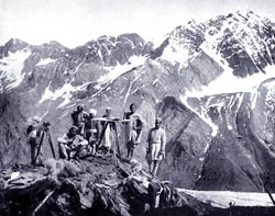 In 2002, the Survey of India began a year-long programme which celebrated 200 years of the Great Trigonometrical Survey (gts), a mammoth cross-country exercise the colonial government undertook in the nineteenth century to map the terrain of the (then) Indian subcontinent. A scientific endeavour that made perfect political and economic sense to the colonial government, the bicentennial celebrations of this event are currently on in the uk.
gts took 65 years to complete. It mapped the entire Indian subcontinent with "inch-perfect accuracy'. The first-ever measurement of the tallest peak on earth