
Dahisar in danger
 The deluge that caught Mumbai by surprise on July 26, 2005 has sent warning signals to areas situated along Dahisar river. The Municipal Corporation of Greater Mumbai's (MCGM's) staff in R-north ward of the Dahisar area, its councillors and residents have woken up to the danger, but some proposed solutions might exacerbate the problem.
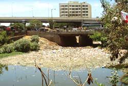
The concern over the state of the river has to do with flooding. The experience with the Mithi river showed Mumbaikars that if rivers remained choked, they would be unable to drain water into the sea when it rained heavily. In this context, the decision to construct two big walls along the banks of the river is as quixotic as it is fundamentally counterproductive. The idea is the brainchild of N V Pai, assistant commissioner, R-north ward, who is leading a crusade to prevent Dahisar river from going the way of the choked Mithi river.
"Without the wall, Dahisar river will face the same encroachment which the Mithi is facing today. The width of Dahisar in most places is 40 metres and I would like to protect that," explains Pai. Environmentalists fear this will turn the river into a nullah and common sense says the high walls will prevent the passage of water to the sea.
But there is some good news. There have been attempts to revive the Dahisar River Restoration Project (DRRP), pre-pared by Mumbai-based Rachna Sansad Institute of Environmental Architecture (RSIEA), which has been on hold.
Dahisar originates in the Sanjay Gandhi National Park and ends at the Mira Bhayander creek. The stretch between Sri Krishna Nagar and the creek is most polluted. Roshni Udyavar of RSIEA says: "The project (DRRP) aims to restore the river and make it perennial by implementing rainwater harvesting in the park through check dams.