
Crop cover insurance
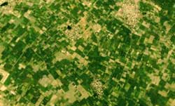 after satellite images being used in town planning, oceanography, military purposes and geographical information systems, the Agriculture Insurance Company (aic) has plans to use them to evaluate insurance claims against crop damage by farmers. aic will focus on wheat crop insurance, launching it in six districts of Haryana and Punjab. In all, these six districts have around one million hectares under wheat cultivation.
"We will assess the claims based on the Normalised Difference Vegetative Index (ndvi), which helps determine the crop vigour or biomass percentage,' said K N Rao, manager (r & d), aic. The index will be sourced from the National Remote Sensing Agency ( nrsa ) and generated by using satellite images of past eight years. Using the index, crop vigour evaluation will be done through images at the peak of the season. aic has hired Risk Management Solutions India and Birla Technology Services to source and process the maps. The insurance, however, is only for the rabi season; during kharif cloud cover blocks the satellite.
aic has already started taking insurance applications. Along with satellite images, it will also use high temperature triggers to evaluate claim payouts. "We use temperature data of the month of March from past 35-40 years to assess land blocks for crop trends,' said Rao. He added that blocks with unstable crop yield trends will have higher premiums. High temperatures could also affect the grain production in wheat and drastically reduce its yield. The maximum payout could be up to Rs 10,000 under both parameters of images and temperature.
Related Content
- Achieving zero hunger in India: challenges and policies
- Order of the Supreme Court of India regarding crop insurance, Anand, Gujarat, 11/08/2021
- Question raised in Lok Sabha on Beneficiaries of PMFBY, 16/07/2019
- Agrarian distress in India: possible solutions
- Oxfam, UN to cushion farmers from losses caused by weather shocks
- Agriculture ministry plans norms to fast-track insurance cover